Quick: Level, from waterdatafortexas.org – | Temperature | (more…)
Contents
General Information …
… and miscellaneous
- en.wikipedia.org/wiki/Lake_Travis
- google.com/search?q=map+of+lake+travis+depth
- fishing-app.gpsnauticalcharts.com/i-boating-fishing-web-app/fishing-marine-charts-navigation.html?title=Travis+boating+app#10.92/30.4275/-98.0436
- Lake Travis is part of The (Texas) Highland Lakes and LCRA operations.
Boat Ramps
Checklists
WIP – Transitioning, NOT yet moved / recreated from v1.jandp.biz/aqua/ (old.jandp.biz/aqua/, just *some* examples
- Checklists
- The three small ‘flip-pages’
- old.jandp.biz/aqua/photos
Diving, Divers
- laketravisscuba.com/
- Texas Treasure Divers – youtube.com/c/texastreasuredivers
- google.com/search?q=lake+travis+divers
- windypointpark.com/scuba-diving/
Emerald Point Marina (‘EPM’)
– Our directions to Safe Harbor Emerald Point, a.k.a. Emerald Point Marina (web page) (2023)
Address: 5973 Hiline Rd, Austin, TX 78734 (Our old directions (PDF; 2020))
– shmarinas.com/locations/safe-harbor-emerald-point/
Events
- google.com/search?q=christmas+parades+lake+travis
- laketravis.com/lake-travis-holiday-events/
- ‘Lake Travis Lighted Boat Parade West’
- (2022: When: Saturday, December 2, 2022 – 6 pm to 10 pm
Where: Crosswater Yacht Club) - google.com/maps/place/Crosswater+Yacht+Club/…
- crosswateryachtclub.com
- crosswateryachtclub.com/events-2/
- (2022: When: Saturday, December 2, 2022 – 6 pm to 10 pm
- ‘Lake Travis Lighted Boat Parade East’
- (2022: : Saturday, December 10, 2022 – 5:30 pm to 9:30 pm
Where: Emerald Point Marina) - Emerald Point Marina (‘EPM’) above
- (2022: : Saturday, December 10, 2022 – 5:30 pm to 9:30 pm
Guides
- 2-page PDF on Lake Travis by J&P (2020)
- 30-page PDF on Lake Travis by J&P (2016, more historical nowadays)
- Photos (just a few selected)
- laketravis.com
Hazards
- Lake Travis Boating Hazards –
montecopeland.com/hazards.html- ‘Travis Anegada’ – N30° 24.480′,W97° 56.784′
- ‘Wall at Arkansas Bend South Cove’ – N30° 24.362′,W97° 56.567′
- ‘ The Great Wall’ – N30° 24.904′,W97° 56.697′
- ‘Graveyard Point’ – N30° 23.266′,W97° 57.463′
- ‘Arkansas Bend Shortcut’ – N30° 24.024′,W97° 56.653′
- ‘Anderson Bend Shortcut’ – N30° 22.720′,W98° 0.678′
- ‘Sometimes Islands Shortcut’ – N30° 23.824′,W97° 54.061′
- ‘Grelle Wall’ – N30° 29.345′,W98° 7.839′ (Mile 47)
- ‘Cow Creek’ – N30° 29.195′,W98° 0.837′ (Mile 32)
Marinas – Slips
- google.com/search?q=marinas+lake+travis
- google.com/search?q=boat+slips+lake+travis+tx
- shmarinas.com/locations/safe-harbor-emerald-point/
Marine Services, Marinas – Service
Boat services – maintenance, repairs
- For Lake Travis, see jandp.biz/aqua/travis/boatservices/
Parks
Photos – Media
A few public photos – v1.jandp.biz/aqua/photos/
Rentals
- google.com/search?q=rent+a+boat+lake+travis
- google.com/search?q=sail+boat+Rental+Lake+Travis
- laketravis.com/best-lake-travis-boat-rentals/
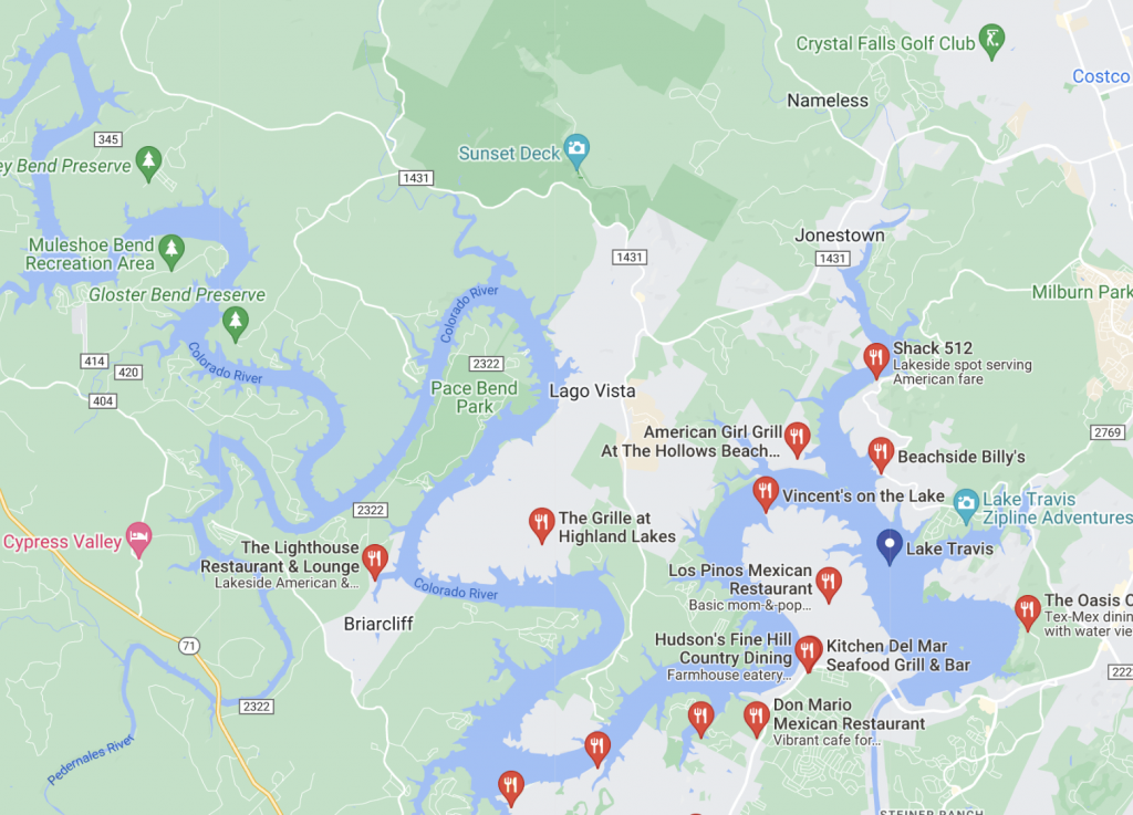
Restaurants
- Mile 7: Beachside Billy’s Restaurant (at Volente Beach)
- Mile 7+: Shack 512 (earlier Nik’s on the Lake) at Sandy Creek Marina / Sandy Creek Yacht Club; Google it
- Mile 9: Vincent’s on the Lake (at Emerald Point Marina)
- Formerly Carlos n Charlies, Frogs on the Pond, Rusty Rudder (2016), Ernie’s on the Lake (2017..),
- Mile 14: Sundancer Grill, Hurst Creek Arm, Google it
- Mile 17: Captain Pete’s Boathouse
- Formerly Gnarley Gar, http://www.golaketravis.com/restaurants/thegnarlygar/ Point Venture; Google it
- Mile 18: not yet researched lake-access: Canyon Grille Rough Hollow, map, at Rough Hollow Club, Google it
- Mile 26: The Lighthouse on the Lake (Briarcliff Marina – google search)
- Google restaurants on Lake Travis
- golaketravis.com/restaurants/ (has errors Aug 2017)
- Google marinas on Lake Travis
- Mile 28: Permanently closed per Google search 2018-03-31:
not yet researched if guest slips: Haven On Lake Travis at The Island, moretherestaurant.com , Haven Bistro On The Lake
Aug 2022:
Towing
| BoatUS | SeaTow | |
| Cost / year (our needs) | $90.00, ‘Unlimited Inland’ | $119.00, ‘Lake Card’ |
| Pros (+), Cons (-) | + Magazine – Call center has a bit to wish for… including their app – have to SAY everything, NO means for them got get access to info via app/IT system |
+ (?) More direct access in the Lake, they are one of the companies operating there ? Not sure SeaTow’s app is that much better |
- boatus.com
- seatow.com/membership/comparison
- laketravis.com/lake-travis/flagship-lake-travis-boat-tow-salvage/
- flagshiptowing.us/
- laketravis.com/lake-travis/lake-travis-vessel-assist/
- google.com/search?q=towing+services+lake+travis
Water – Level, Temp, …
(For more on how water is flowing into the lake, see The (Texas) Highland Lakes and LCRA operations.)
- Level
- Level @ Mansfield Dam (3963) – https://hydromet.lcra.org/home/GaugeDataList/?siteNumber=3963&siteType=lakelevel
- hydromet.lcra.org/riverreport/ – current lakes’ levels, 7 Days Ago, 30 Days Ago
- waterdatafortexas.org/reservoirs/individual/travis – graphic showing data over last 12 months, three tabs:
- Recent
- Historical
- Statistics
- google.com/search?q=lake+travis+water+level
- Temperature
more – seems more current, up-to-date
more / old / …
- wwwext.arlut.utexas.edu/weather/lake/ – BUT, been wrong for a while (2020sh)
- which impacts old.jandp.biz/aqua/travis/
- also referenced by laketravisscuba.com/weather
- just approximation based on air, and cabe be WAY OFF if (e.g.) rains lakemonster.com/lake/Texas/Lake%20Travis-water-temperature-194
- google.com/search?q=water+temperature+lake+travis
Basic Info
Extract from waterdatafortexas.org/reservoirs/individual/travis:
| Impoundment date | 1942-01-01 | |
| Vertical datum | NAVD88 +0.6 | |
| Dead pool elevation | 535.75 ft above NAVD88 +0.6 | |
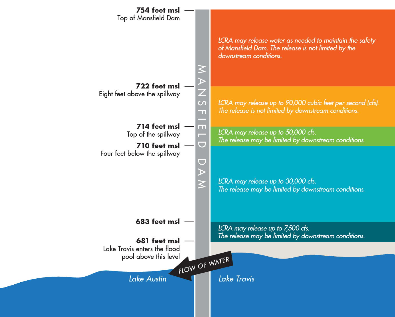
| Emergency spillway crest elevation | 714.00 ft above NAVD88 +0.6 | 172% av full capacity (1.9/1.1) “Top of spillway”, “Lake Travis is designed to hold an additional 776,062 acre-feet of floodwaters in what is referred to as the flood pool.” [1] (1.1+~0.8=1.9, which is similar to the 1,921,731 acre-feet in [2]) |
| Flood pool elevation | 721.40 ft above NAVD88 +0.6 | |
| Maximum design elevation | 745.00 ft above NAVD88 +0.6 | |
| Top of dam elevation | 750.00 ft above NAVD88 +0.6 | |
| Conservation pool elevation | 681.00 ft above NAVD88 +0.6 | FULL lake, 100% capacity. “Lake Travis is considered full for water supply purposes at 681 feet msl. At that level, the lake contains 1.1 million acre-feet of water.” [1] |
| Data download (CSV) | period of record, last one year, last 30 days |
[1] “Lake Travis is the only lake in the Highland Lakes chain specifically designed to hold back floodwaters. Lake Travis is considered full for water supply purposes at 681 feet msl. At that level, the lake contains 1.1 million acre-feet of water. Lake Travis is designed to hold an additional 776,062 acre-feet of floodwaters in what is referred to as the flood pool.” [lcra.org/water/dams-and-lakes/]
[2] “The maximum design water surface may reach to 748.9 feet above mean sea level. According to the TWDB 2008 volumetric survey (LiDAR dataset), Lake Travis has a storage capacity of 1,134,956 acre-feet encompassing a surface area of 19,297 acres at conservation pool elevation (681.6 feet NAVD88). At the flood pool elevation 714.6 feet above mean sea level (NAVD88), the total storage capacity of Lake Travis is 1,921,731 acre-feet, encompassing a surface area of 29,160 acres. The drainage area above the dam is 38,130 square miles, of which 11,900 is probably noncontributing. Runoff is partly regulated by Lake Buchanan and other reservoirs upstream.” [twdb.texas.gov/surfacewater/rivers/reservoirs/travis/index.asp]
From en.wikipedia.org/wiki/Lake_Travis:
| Location | Travis / Burnet counties, northwest of Austin, Texas |
|---|---|
| Coordinates | 30°23′31″N 97°54′24″W |
| Lake type | Hydroelectric reservoir |
| Primary inflows | Colorado River |
| Primary outflows | Colorado River |
| Basin countries | United States |
| Surface area | 18,930 acres (7,660 ha) |
| Max. depth | 210 ft (64 m) |
| Water volume | 1,130,000 acre⋅ft (1.39 km3) |
| Shore length1 | 270 mi (434 km) |
| Surface elevation | |

From lcra.org/water/floods/key-elevations-for-lake-travis-during-floods/:
Records – Water Level
From lcra.org/water/dams-and-lakes/ (go to Lake Travis section and expand it): (R:2025-07-17)
Top 10 highest levels for Lake Travis
| Rank | Date | Height* (feet msl) |
|---|---|---|
| 1 | Dec. 25, 1991 |
710.44 |
| 2 | May 18, 1957 |
707.38 |
| 3 | June 26, 1997 |
705.11 |
| 4 | Feb. 8, 1992 |
704.83 |
| 5 | Oct. 20, 2018 | 704.39 |
| 6 | July 6, 2007 | 701.52 |
| 7 | Nov. 24, 2004 |
696.70 |
| 8 | June 14, 1987 |
693.48 |
| 9 | July 7, 2002 |
693.47 |
| 10 | June 7, 2016 | 692.70 |
Lowest Lake Travis Elevations
| Rank | Drought | Date | Height* (feet msl) |
|---|---|---|---|
| 1 | 1947-57 | Aug. 14, 1951 | 614.18 |
| 2 | 1963-64 | Nov. 8, 1963 | 615.02 |
| 3 | 2008-16 | Sept. 20, 2013 | 618.56 |
| 4 | 1983-84 | Oct. 7, 1984 | 636.58 |
| 5 | 1999-2000 | Oct. 15, 2000 | 640.24 |
| 6 | 2005-06 | Dec. 13, 2006 | 643.55 |
*Based on daily readings at 8 a.m.
BUT – TABLE ABOVE hasn’t been updated – e.g. 2023 is missing. There are more “discrepancies”, at least compared to golaketravis.com/waterlevel/ though this can (only) partly depend on what measurements are used (e.g. daily average or at a specific time of day).
From GoLakeTravis R:2025-07-17:
Highest Historic Flood Levels – Lake Travis
|
Rank |
Date |
Height (msl) |
|---|---|---|
|
1 |
Dec 25, 1991 | 710.44 |
|
2 |
May 18, 1957 | 707.38 |
|
3 |
June 25, 1997 | 705.11 |
|
4 |
Feb 9, 1992 | 704.68 |
| 5 | Oct 20, 2018 (most recent) | 704.39 |
|
6 |
July 6, 2007 | 701.51 |
|
7 |
Nov 25, 2004 | 696.70 |
|
8 |
July 7, 2002 | 693.50 |
|
9 |
June 14, 1987 | 693.48 |
|
10 |
June 16, 2016 | 692.69 |
Lowest Historic Drought Levels – Lake Travis
|
Rank |
Date |
Height (msl) |
|---|---|---|
|
1 |
Aug. 14, 1951 | 614.18 |
|
2 |
Nov. 8, 1963 | 615.02 |
|
3 |
Sept. 20, 2013 | 618.64 |
|
4 |
Nov. 15, 2014 | 622.65 |
| 5 | Oct. 25, 2023 (most recent) | 626.93 |
|
6 |
Oct. 4, 2009 | 629.83 |
|
7 |
Oct. 7, 1984 | 636.58 |
|
8 |
Oct. 15, 2000 | 640.24 |
|
9 |
Dec. 13, 2006 | 643.55 |
* msl: mean sea level; height is feet above msl
* 681 feet msl: Lake Travis is considered full for water supply purposes at 681 feet msl
Weather
- Wind – our own page
- swedeteam….com/wind/ – include speed calculator (m/s, km/h, mph, knots) (not yet the most mobile/small-screen adapted)
- en.wikipedia.org/wiki/Beaufort_scale
- Lake Travis
- North Shore Marina – sailflow.com/spot/163218
- Windy Point Park – sailflow.com/spot/533733, requires Pro subscription
- Galveston Bay (/travel/us/tx/kemah/)